Mannar City
Mannar is the main town of Mannar District, Northern Province, Sri Lanka. It is governed by an Urban Council. The town is located on Mannar Island overlooking the Gulf of Mannar and is home to the historic Ketheeswaram temple.
Mannar Fort
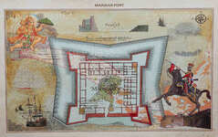
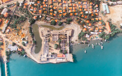
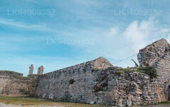
Mannar Island is part of Mannar District, Sri Lanka. It is linked to the main island of Sri Lanka by a causeway. It has an area of about 125 square kilometers, mainly covered with vegetation and sand. At entrance point where the current road over the causeway connects to the bridge lies the ancient Fort built by the Portuguese. The Portuguese chronicler and geographer António Bocarro who served as chronicler-general of the Portuguese State of India, has provided a map and a description of the Portuguese Fort as in 1635. It was built by Lopo Soares de Albergaria in the year 1518 and is square shaped, as can be seen in the plan which is an very rough drawing of the island and the fort (see below). The stretches of ramparts which run from one bastion to another between the three bastions, with which this fort is equipped are of little importance, being less than two fathoms (3.6 meters) in height, but with the parapets and the thickness of wall being six spans (1.4 meters) and each stretch of rampart being eight fathoms (14.6 meters) long and each of the two sheltered bastions being taller than the rampart and the bastion on the bay side being still lower than that facing the mainland.
Bocarro also states that the fort was at one time very wealthy and earned much revenue from the seed pearl fishery that used to be held within the area coming under it. With the depletion of the pearl oysters he states what then exists is only a relic of its old grandeur of the fort. The fort was captured by the Dutch in 1658 after much resistance from the Portuguese but other than reinforcing the fort, no significant change was done to the fort. This fort was inaccessible to the public for decades due the LTTE Terrorist activities in the area. Once the LTTE was destroyed in 2009 this area was opened to the public transport. Now the area surrounding the fort is used by the police department. But public are not restricted from visiting the fort.
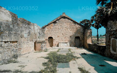
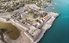
The Mannar Fort has four bastions and it’s still in good condition although the buildings inside the fort have not been properly maintained. You can roam around the fort with no restrictions. Access to the top of the ramparts is on the left after entering the fort. From here you can walk all around the fort getting a birds eye view of the ruined buildings inside. On two ends of the building square, you will see two rooms with no door or windows. The top has been covered by a now broken slab on large iron bars. The only access to these rooms are some tiny steel steps mounted on one side of the wall. These two rooms might have been prison cells at one time. In addition you can see what looks like a church among the buildings. Two watch towers still stand tall on 2 edges. One is almost broken away form the fort and may drop in to the ocean very soon.
About Mannar District
Mannar is the capital of Mannar District, Sri Lanka. Mannar District is located in northwestern Sri Lanka. It is one of five administrative districts of the Northern Province. The district covers 2,002 sq. km, approximately 3% of the total land area of Sri Lanka. Geographically the bulk of Mannar is on the mainland within the arid and dry zone. High temperatures and low rainfall characterize the climate. The monthly temperatures range between 26.5°C and 30.0°C with highs normally recorded between May and August. Mannar receives nearly 60% of its rainfall during the northeast monsoon, which lasts from October through December. The land area is relatively flat and sits at low elevations. Towards the interior the terrain is gently undulating, favoring the storage of rainwater in tanks that provide the majority of the irrigation for the district's arable land. The primary economic activities in Mannar are crop cultivation (mainly paddy), fisheries and animal husbandry. Employment opportunities in the district are highly seasonal, and there are no institutional facilities for tertiary education.
About Northern Province
The Northern Province is one of the 9 provinces of Sri Lanka. The provinces have existed since the 19th century but they didn't have any legal status until 1987 when the 13th Amendment to the 1978 Constitution of Sri Lanka established provincial councils. Between 1988 and 2006 the province was temporarily merged with the Eastern Province to form the North-East Province. The capital of the province is Jaffna.
Northern Province is located in the north of Sri Lanka and is just 22 miles (35 km) from India. The province is surrounded by the Gulf of Mannar and Palk Bay to the west, Palk Strait to the north, the Bay of Bengal to the east, and the Eastern, North Central and North Western provinces to the south. The province has a number of lagoons, the largest being Jaffna Lagoon, Nanthi Kadal, Chundikkulam Lagoon, Vadamarachchi Lagoon, Uppu Aru Lagoon, Kokkilai lagoon, Nai Aru Lagoon, and Chalai Lagoon.Most of the islands around Sri Lanka are to be found to the west of the Northern Province. The largest islands are Kayts, Neduntivu, Karaitivu, Pungudutivu, and Mandativu.
The Northern Province's population was 1,311,776 in 2007. The majority of the populations are Sri Lankan Tamils, with a minority Sri Lankan Moor and Sinhalese population. Sri Lankan Tamil is the major language spoken in the province by the vast majority of the population. The other language spoken is Sinhala by 1 percent of the population. English is widely spoken and understood in the cities.
【Text by Lakpura™. Images by Google, copyright(s) reserved by original authors.】

